Hanline Ranch
There's easy parking here. I often use it to keep my rig off the main road.
The paved road ends just beyond Hanline Ranch at N 35° 00.639' W 119° 30.335'
|
Hanline Ranch
|
|
||||
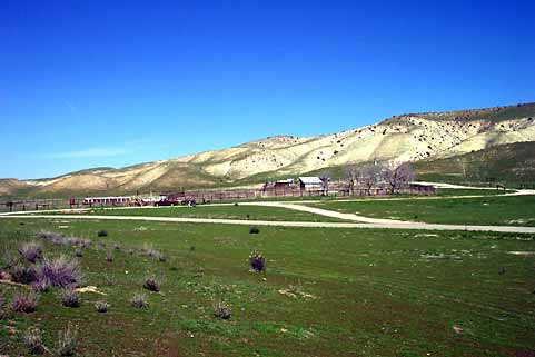
| The remnants of the Hanline Ranch can be found adjacent to Soda Lake Road at N35° 00.258 W 119° 30.335', 0.7 miles North of the Pipeline Canyon Road intersection. BLM has some signs posted that indicate you should not go into the buildings. I've seen this area used as staging by horsemen for various kinds of rides.
There's easy parking here. I often use it to keep my rig off the main road. The paved road ends just beyond Hanline Ranch at N 35° 00.639' W 119° 30.335' |
|||||
| Soda Lake Road is left to right across the center of this photo. | |||||
| Not visible here, but just behind me is a road ( N 35° 00.131' W 119.30.213') that takes you up to Quail Springs Road. 1.0 mile up there's a wire gate, then over another hill to the Quail Springs intersection. At the intersection, left takes you over to Pipeline Road, right and you ride back down Quail Springs to Soda Lake Road or take the cut-over to Padrone Canyon. This little road is easy and offers some good views. The road takes off from a point on Soda Lake Road about 50 yards or so to the right of the right edge of this photo. You can't miss it. The road goes up to and passed a water trough that you can see from Soda Lake Road. | |||||